Visualiser Les Vents Sur Terre En Quasi Temps Réel
Deux liens plutôt sympa,
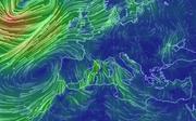
le premier http://earth.nullsch…53.27,41.11,470. Il s’agit d’une carte de la terre où les vents sont représentés par des animations en fonction de leur vitesse, c’est une carte quasi temps réel à partir des données du Global Forecast System.
Le second http://www.slate.fr/monde/81367/vents relate la prolongation d’un projet artistique pour visualiser la carte des vents aux Etats-Unis avec des animations à un projet plus global.
Voir la nouvelle rubrique Météo:ANALYSE DE LA SITUATION MÉTÉO SUR UNE SEULE PAGE